
KEY IDEAS:
- The Amarillo Police Department needed to improve crime analysis, incident response, and communication in its real-time information center (RTIC).
- Fragmented police data across CAD, RMS, and other systems delayed access to time-sensitive information and limited real-time visibility for officers in the field.
- Police data integration reduces manual data reconciliation, minimizes context switching, and creates a shared operational picture.
- With unified data, Amarillo PD accelerated investigations, surfaced critical leads, improved officer safety, and optimized drone deployment.
“Real-time crime fighting is changing – simply reacting isn’t enough. We are building multiple layers of technology that can mitigate emergent crime until our officers can respond, and we want to equip them with the information they need to respond fast and stay safe.”
Lt. Shane Chadwick
Amarillo PD, Texas

AMARILLO, Texas — Real-time information center (RTIC) response coordination is measured in seconds. RTIC personnel must:
- Quickly identify critical information
- Make connections across historical and real-time data sources
- Share actionable insights with officers in the field
However, without the right technology, that process can take minutes or hours.
When the Amarillo Police Department designed its Regional Crime Center (RCC), the agency’s version of an RTIC, command staff knew their personnel needed immediate access to meaningful data in real time. To eliminate friction and information delays at the RCC, Amarillo PD onboarded Peregrine as its data integration solution.
With access to contextualized data in a unified platform, Amarillo PD’s crime analysts can find and disseminate meaningful information in seconds, resulting in faster investigations, more cases closed, and effective drone deployment. Keep reading to learn how data integration powers real-time operations at Amarillo PD.
💡 WHAT IS A REAL-TIME INFORMATION CENTER (RTIC)?
- RTICs are a central hub where personnel receive, analyze, and share intelligence.
- RTICs bring together historical and real-time inputs.
- RTICs provide real-time awareness to officers in the field, enhancing safety.
- RTIC personnel help gather evidence and support investigations.
Why fragmented police data slows real-time information center operations
RTIC personnel leverage dozens of historical and real-time data sources to find critical information to support officers in the field. However, because most police systems weren’t designed to communicate, RTIC personnel have to individually access each system.
READ MORE → What Is a Real-Time Information Center (RTIC) in Policing?
Every second counts in real-time operations, but RTIC personnel are often forced to waste time flipping between program to program. They must manually search for:
- Geospatial and video data from drones
- Citations
- Warrants
- Computer-aided dispatch (CAD) system data
- Records management systems (RMS) data
Fragmented data meant that Amarillo PD’s real-time analysis wasn’t actually done in real time. Full person and location workups — understanding what cases, known associates, vehicles, incidents, and other data are associated with a person or a location — “took us hours,” said Haley Hernandez, a Crime Analyst Supervisor at the Amarillo Police Department. “That information is spread across different systems. It takes time to find, pull, and correlate disparate data.”
As a result, RTIC personnel are constantly context switching, manually sifting through a bevy of information to find time-sensitive insights. That complex process has negative impacts on real-time operations. To overcome these limitations, Amarillo PD needed a way to unify its data and deliver real-time visibility across systems.
🔑 KEY TAKEAWAY: Fragmented police systems prevent real-time operations by forcing analysts to manually search, correlate, and analyze data across multiple platforms.
Why real-time visibility is critical for police RTIC operations
To be effective, RTIC personnel need immediate access to timely, actionable insights. When they’re forced to manually navigate disconnected systems, personnel:
- Risk missing critical insights due to information overload
- Can’t effectively provide real-time awareness to officers in the field
- Can’t draw connections across disparate data sets
- Can’t identify emerging patterns to stay ahead of crime
When police departments are in this constant state of reaction, they lose efficiency. Reactive departments can’t develop long-term solutions that help prevent and mitigate crime. That strategy doesn’t work in today’s fast-changing environment.
🔎 HOW DOES REAL-TIME VISIBILITY IMPROVE OFFICER SAFETY AND RESPONSE?
- Provides more context on people, locations, and vehicles
- Helps officers identify potentially dangerous conditions
- Allows officers to prepare before arriving on scene
- Enables better, more informed decisions
“I’ve been to a lot of real-time crime centers,” Lt. Shane Chadwick, Commander of the Amarillo Regional Crime Center told us. “Real-time crime fighting is changing — simply reacting isn’t enough. We are building multiple layers of technology that can mitigate emergent crime until our officers can respond, and we want to equip them with the information they need to respond fast and stay safe.”
Amarillo PD needed a common operating picture that responding officers, RTIC personnel, and law enforcement leadership could all leverage in parallel — in real time.
🔑 KEY TAKEAWAY: Real-time visibility enables RTIC personnel to move from reactive response to proactive decision-making by surfacing critical insights as incidents unfold.
How Amarillo PD unified police data to power its real-time information center
To enhance situational awareness and build a shared operational picture, Amarillo PD implemented Peregrine as its unified data platform. Peregrine supports Amarillo PD’s mission-critical incident response by integrating and operationalizing data from more than 10 data sources, including:
- Amarillo PD’s CAD and RMS systems
- Evidence and citations databases
- Geospatial information system
- AVL, city- and state-run crash and utility databases
- Other internal and external data sources
🔎 HOW CAN POLICE DEPARTMENTS UNIFY DATA FROM MULTIPLE SYSTEMS?
Data integration solutions help police departments unify data across disconnected systems, including CAD and RMS systems, real-time inputs, and external data sources. Unified data platforms ingest, clean, and standardize raw data to provide a common operating picture.
Using Peregrine, RCC personnel can search across all of Amarillo PD’s data sources in a unified platform. Peregrine harmonizes the agency’s historical, real-time, and external data sources, automatically surfacing connections between disconnected data sources.
“I needed Peregrine because I wanted all my data in one spot so my searches would be quicker. Speed is critical,” he continued.
Data integration allowed Amarillo PD to shift from fragmented information gathering to high-impact, real-time workflows.
💡 WHAT ARE THE BENEFITS OF CENTRALIZED DATA FOR REAL-TIME CRIME CENTERS?
- Reduces tedious context switching and manual analysis
- Surfaces obscure connections to provide situational awareness
- Delivers contextualized, actionable insights in seconds
How Amarillo PD uses unified data to support real-time policing operations
Since implementing Peregrine, Amarillo PD has been able to support all aspects of the department through its real-time operations. Here’s how connected data enhanced investigations, operational efficiency, and real-time visibility at Amarillo PD.
💡 AT A GLANCE: Data integration enhances real-time operations at Amarillo PD by…
- Enabling search across all police data in one platform
- Configuring automated alerts to reduce response times
- Visualizing calls for service to optimize drone deployment
- Delivering real-time insights to officers in the field
Search across unified data to streamline investigations
With a unified data platform, full person and location workups now take minutes, not hours.
“With Peregrine, we do a one-time search,” Hernandez said. “It’s easy. If you don’t know exactly what direction to take an investigation and you type key words into Peregrine, you’ll find out pretty quick if you’re on the right track.”
Instead of wasting time on manual analysis, Amarillo PD’s crime analysts can focus on higher-value work that supports investigations and other police priorities.
“Our analysts are awesome at solving crimes. They build a lot of dashboards that include crime trends, response times, geospatial analysis, you name it. Tasks that used to take hours are now completed in a fraction of the time,” Chadwick said.
🔑 KEY TAKEAWAY: Unified data eliminates investigative bottlenecks by enabling full person and location workups in minutes instead of hours.
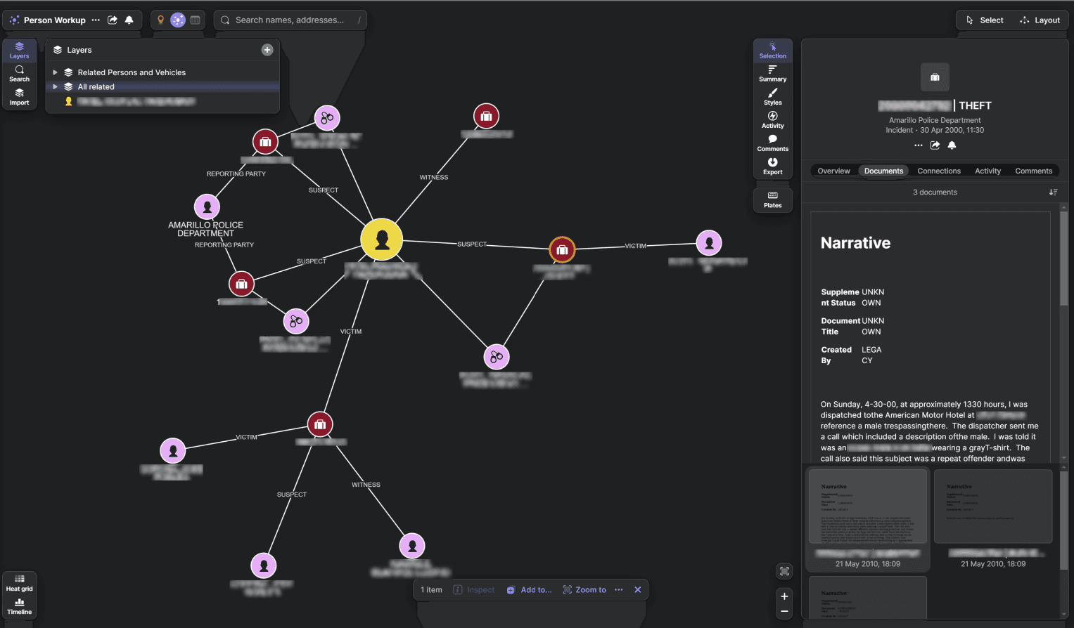
The above image contains notional data.
Use automated alerts to respond faster to incidents
RCC analysts reduce friction during incident response by configuring automatic alerts through Peregrine.
“We also use alerts and notifications through Peregrine,” Hernandez said.”So, if there’s a CAD call with certain key words, we find out in real time. That means my team of analysts can respond to incidents and kickstart the investigative process more quickly.”
📖 CASE STUDY:
- Unified data and automated alerts helped the Amarillo PD apprehend three individuals, now in federal custody, involved in seven different aggravated robbery incidents.
- Hernandez explains: “I had an alert set up for the word ‘robbery.’
- “One night around 10 p.m., I get a notification a robbery occurred.
- “So, I distribute the information, and our team found video with a suspect vehicle, which led to a lead suspect. We’d been working to apprehend this individual for two months or so, and we had a tip this individual had an associate who was with them during the robberies.
- “The investigation continues, and we’re able to arrest the primary suspect and two co-conspirators.”
Use geospatial data to deploy drones effectively
Chadwick and Hernandez also explained they combine data on 911 calls with potential drone locations; if there is an emergent issue with a drone nearby, they can use the aircraft as a quick, initial response before officers arrive on the scene.
Chadwick explained that when there is an emergency, the goal is to have a drone on location within 90 seconds more than 90% of the time. “We hit the 90 second threshold about 98% of the time. Peregrine helped us figure out where to have our drone sites because we were able to filter calls for service relative to the locations of our drones.”
Peregrine also helps push context gathered by aerial video footage to officers in the field, keeping them safer and improving incident response. “That process went from about an hour to three minutes,” Hernandez said.
🔑 KEY FACTS: Amarillo PD deploys drones within 90 seconds in ~98% of emergency responses, enabled by…
- Unified data visualization of calls for service
- Optimized drone site placement

The above image contains notional data.
Improve real-time visibility for officers in the field
Identifying and curating information officers need, like full person and location workups along with drone mapping quickly, is only half the battle. The other half? Equipping officers in the field with that information.
Patrol officers need information they can easily access and digest to make better decisions and respond effectively to whatever situation they face while keeping their communities safe. Peregrine’s mobile app is specifically optimized for information consumption in the field.
READ MORE → Empowering Patrol Officers With Real-Time, Critical Information
Chadwick agrees. “The ability to swiftly access reports from RTCC personnel and conduct location searches directly in the field has been a game-changer for our department,” he said. “My team in the field is great. Peregrine makes them better.”
🔑 REAL-WORLD IMPACT OF UNIFIED DATA AT AMARILLO PD:
- Full person and location workups: hours → minutes
- Drone intel delivery to officers in the field: ~60 min → ~3 min
- Drone response in emergencies: 90 seconds in ~98% of cases
- Multi-incident suspects identified and apprehended
How data integration transforms real-time operations
Effective real-time operations require more than just data. RTIC personnel must be equipped with clear, actionable insights when it matters most. Data integration reduces noise, creates a shared operational view, and allows personnel to quickly access the information they need. Data integration solutions:
- Harmonize information from previously disconnected data sources
- Provide a centralized platform that surfaces connections across systems
- Enable fast, accurate analysis of dynamic situations
- Support real-time data sharing with officers in the field
READ MORE → Standing Up Your RTCC: An Accessible Guide for All Agencies
By unifying data across systems, Amarillo PD transformed its RCC into a centralized hub for real-time intelligence:
- Crime analysts can now generate full person and location workups in minutes, not hours.
- Officers in the field receive timely, contextual insights that improve decision-making and safety.
- Automated alerts and geospatial analysis allow the department to respond to incidents faster.
With unified data, real-time information centers can shift from reacting to incidents to anticipating and disrupting crime as it happens. For agencies looking to enhance their real-time capabilities, Amarillo PD’s approach highlights what’s possible when data is connected, accessible, and actionable.
“Better information leads to safer communities,” said Hernandez. “We’ve been able to more effectively solve and disrupt violent crimes in our communities with Peregrine.”
To learn how Peregrine can support real-time operations at your agency, request a demo today.
Peregrine is built on AWS GovCloud.


 Your Privacy Choices